Two hundred fifty two days have passed since my last post. Much has taken place during that time and this medium and space are insufficient to relay all the stories. Leaving my personal life aside, all the things that are taking place around the world would be enough to keep me from writing more. I can not isolate myself anymore. I should return to writing.
Next to a linguist, a cartographer is a valuable friend that a historian can have. Maps are one of the best tools in studying history. Most of the pre-satellite era maps were approximate (read: inaccurate) representations of the space that we occupy, but with the right person holding those maps, we traversed continents to and fro. Even an illiterate nomad uses maps, not paper or cloth maps, but three dimensional ones in his mind; a tree, a hill, a river or even the stars, those are his legends to follow from pasture to pasture. Our curiosity is our compass.
In the beginning of this summer, I stumbled upon a gallery on Madison Avenue. A banner hang by its entrance that read: The Most Important Maps in American and European History. How could I pass up such opportunity? Besides I had about fifteen minutes to spare before my meeting. And so I ventured into the gallery only to discover the world beyond my imagination. A young lady, whose name I no longer remember, was kind enough to inform me that I was free to walk around and even take photographs. One of the coolest maps I saw was an art work of a French cartographer depicting "Asia at the height of French influence-7 years before the Revolution". I was mesmerized by the work so much that I did not notice the price tag of $25000.

It was large, very large indeed, clear and well preserved, and right in the center of it was something familiar. The words were in foreign language, but they were familiar to me. I read them silently: Belch, Alsogd, Alshash, Chowarezem, Chorasan, Cabul. But my mind excitedly understood them as Balkh, Sogdiana, Shash (old name of Tashkent), Khorazm, Khorasan, Kabul. I studied the map for few more minutes and recognized a territory that I know as Khanate of Bukhara, established by the Manghits, an Uzbek dynasty. The cartographer depicted the kingdom as Vsbeck Mawaralnahra, which means Usbeks of the Land Beyond the River. And the river of course Amu Darya, which the cartographer noted as Iihun fl., clearly Latinized from Arabic (fl. is abbreviation of fluvio, Latin for river).
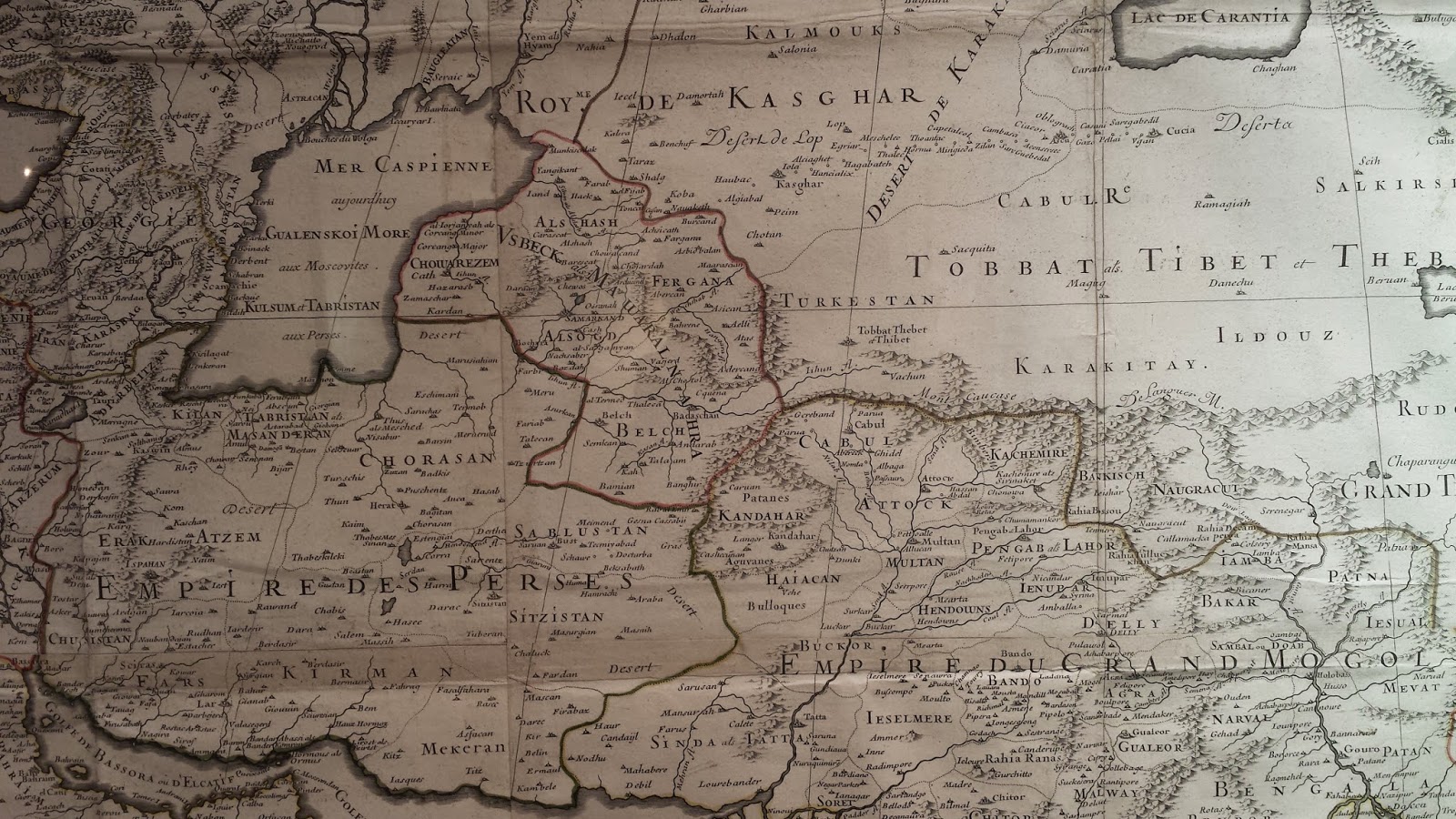

It is interesting to note that names of countries and cities appear intermittently in either Latin or Arabic, or some combination of the two. Whereas both the region and city of Balkh are spelled as Belch (Latin? French?), the region and city of Tashkent are clearly in Arabic, Alshash. Region is Fergana, but city is Fargana. Region is Alsogd and city is Samarkand. Bochara is Bukhara, al-Termed is Termez and Badaschan is Badakhshan, but the best of all is al Wachshab fl. that stands for the river Vakhsh. Peculiarly in Khorezm, there are Corcang Minor and Corcang Major, which could correspond to our understanding of Old Urgench and New Urgench. And the most confusing are three variations of names of Tibet: Tobbat Thebet at Thibet. Pick one you like.
Despite the artistic component of the map (mountain chains, wavy rivers, and colorful borders), the map has one easily noticeable error. It shows the rivers Amu and Syr (Sihun als Alshash) flowing into the Caspian Sea (Mers Caspienne) and the Aral Sea is nowhere to be found on the map. I hope, time permitting, to make a list of all the geographic locations as depicted on this map and find their modern equivalent.
In the meantime, if you thought that the above map was cool, check out what I saw next. This one was the work of an Italian by name of Giacomo Gastaldi, and the price tag was ten times higher than the one before. This map also dated from much earlier period, two hundred years earlier (Gastaldi died in 1566) and it is called: NOVA ET ACVRATA TOTIVS ASIӔ TABVLA. This basically translates to "New and Accurate Map of Entire Asia".

Artistically speaking, the Italian is more skillful than the French (look at the caravans of camels, elephants and rhynos(?) in India, and those bright orange tents of the Mongolians!), but his map too shows the Iaxartes (Amudarya) and Oxus (Syrdarya) flowing into the Caspian Sea (MARE CASPIVM) without any depiction of the Aral Sea. This makes me think that the Aral Sea is a new phenomenon, or simply, the cartographer did not have sufficient information about the region.


Actually, the fact that all the names of locations appear in Latin indicates that Gastaldi did not have access to non-Western sources. In fact, his MAV-RE-NACHER is on the other side of Syrdarya, instead of describing territories between the two rivers. Gastaldi's description Samarchand magni Tamberlanis quondam sedes (Samarkand, the former seat of the great Tamerlane) may also indicates that his information was a bit out of date. This was not by accident though, as the cartographer was born ninety five years after the death of the Mongol conqueror. In fact, by 1500s power of the Timurids had waned and Uzbeks under Shayban had began their penetration into the Central Asian Proper. Constant wars in the area would have prevented not only the Europeans like Gastaldi from traveling into but also the merchants traveling out of the region. If there is no trade, there is no news.
This map too would be worth the time to match all the names of towns and cities to their current equivalents. Many of these are beyond recognition, once again because of the source of information; it is very likely that the Latin names represent ancient settlements, perhaps even from the time of Ptolemy that were no longer extant when Gastaldi was working on the map. Obviously Bvccara is Bukhara and Charassan is Khorasan, and it it possible that incorrectly placed Chendibadau is actually Konibodom. Agriandisan may be Andijan, and though hard to believe, it is probable that Cicugiend is modern Khujand.
Whatever the current names may be of the names of settlements, cities, rivers, deserts, mountains and so on, one thing is certain, the map is really beautiful. Though not exactly "acvrata", it still looks like a lot of work went into making of the "Asiӕ
Tabvla". If you don't recognize any names, or learn anything interesting, you can at least enjoy the workmanship of the cartographers. I do think the creative parts of the maps only add to their value, but I can't explain the big gap between their prices. If I sold Gastaldi's map, I could buy a really nice house in Omaha.


Update from friend, via sms: News of the existence of the Aral Sea only reached Europe in the 17th century and caused amazement / Previous Western travelers had somehow overlooked it, and it was a surprise to discover such a huge unknown body of water so close to the edge of Europe. / It is much more likely that the name dates from the 17th century. Abu'l Ghazi Khan, who died in 1664, wrote that he was proclaimed Khan in the country called Aral, "which is one the course of the Amu that falls into the sea". The term Aral appears a little later in the form of "Aral More" on a Russian chart dated 1697
My friend also offered the following website for additional information on the Aral: www.karakalpak.com/stanaral.html
Second Update (Sep. 30, 2014):
Four days ago, people at NASA published two images of the Aral Sea, which you can view below. The images were part of an article titled The Aral Sea Loses Its Eastern Lobe and represent the rapidity of the evaporation of this body of water. Global warming is only one of the reasons for lose of water in the Aral, the other is over irrigation of both of its tributaries, the Amu and Syr rivers. This is one of the worst ecological legacies from the Soviets and unfortunately, current governments of the countries surrounding the Aral are not doing anything to fix the problem. In another ten years, when the remaining pools of the Aral Sea are no more, the Tour/Jaillot and Gastaldi maps (see above) will not be so erroneous.

